Lake Travis Map – Popular Boating Spots
West Beach Marina (512) 266-2277 17317 West Beach Road – Austin TX 78734
View Lake Travis Map in a larger map |
Interactive Map of Lake Travis – Marinas, Restaurants and Boating
This Google Map of Lake Travis shows the eastern end of the lake between Lakeway and Mansfield Dam. On the chart Lake Travis is shown in light blue and major roads in yellow. You can view an overhead satellite image or terrain contours by clicking on the Sat(ellite) or Ter(rain) buttons in the upper right corner. And you can zoom in or out by clicking the + or – symbols in the upper left corner.
From Ranch Road 620, follow the purple line up Hudson Bend to West Beach Marina. Flat terrain and easy lake access make WBM the best Lake Travis marina. We’re just a few minutes drive from Lakeway, Cedar Park or Steiner Ranch. Other markers on the chart show some of our favorite restaurants, swimming holes, boating and recreational spots (click on the blue Lake Travis map markers for details):
Devil’s Cove – great place for rafting up and party boats
Sandy Creek – wide creek leading north from Lake Travis’ main basin
Starnes Island (aka Rattlesnake Island) – popular anchorage for party boats
Mansfield Dam – built in 1941 to create Lake Travis and provide flood control
The Oasis – restaurant overlooking the lake, great sunsets!
Cypress Creek – popular inlet for boating, swimming, fishing and scuba diving
Hippie Hollow – clothing-optional beach, northeastern shore of main basin
The Gnarly Gar – restaurant on the north shore, boat accessible
West Beach’s central location makes it convenient to get to these destinations quickly without expending a lot of fuel. Devil’s Cove, easily the most popular spot on Lake Travis for parties and on-the-water get-togethers, is just a few minutes away. And, unlike other marinas located on shallow inlets or narrow coves, West Beach has unobstructed access to deep water — regardless of the lake level. Check out our Lake Travis boat slip prices.
Bottom Contour Map – Lake Travis (LCRA 1995)
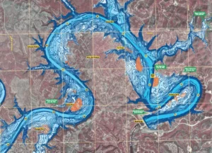
The above chart is a color-coded sonar mapping of Lake Travis water depths from Lakeway to Mansfield Dam, created by the Lower Colorado River Authority (LCRA). The darker blue colors indicate deep water, lighter blue moderate depths, and the really shallow spots are shown in orange.
Few maps of Lake Travis show detailed bottom contours and obstacles. So it’s a good idea to get a special Lake Travis map that shows the water depths. Bottom contour maps are especially useful for navigation, fishing and scuba diving when the lake level is low.
The average level of Lake Travis is 670′ above MSL, and it is considered full when the water is at 681’. At that level, the lake is 210’ deep at its deepest point (near Mansfield Dam).
The highest Lake Travis water level ever recorded was 710.4’ (December 25, 1991); and the lowest 614.2’ (August 14, 1951). The Mansfield Dam spillway is 714’ above MSL and the 100 year flood plain is at 722′. The LCRA would likely open flood gates to release water downstream before the lake reaches this level, to limit flooding and avoid compromising the structural integrity of the dam.
Please read the Lake Travis marina ratings and reviews our customers have written. But the best use of this Lake Travis map is to find your way to our marina!
Call today to learn about boat slip options for new members!
West Beach Marina (512) 266-2277 17317 West Beach Road – Austin TX 78734